2023-7-5 11:12:0 Author: paper.seebug.org(查看原文) 阅读量:57 收藏
Author: [email protected] 404 Team
Chinese version: https://paper.seebug.org/2087/
0x01 GeoServer & GeoTools
GeoServer is an open source software server written in Java that allows users to share and edit geospatial data. GeoServer is primarily built on the Spring Framework and uses the GeoTools libraries.
GeoTools is an open-source Java library that provides tools for geospatial data. GeoServer uses GeoTools for many of its core functionalities, such as data reading, writing, and transformation.
0x02 Vulnerabilities Introduction
GeoServer and GeoTools have released CVE-2023-25157 and CVE-2023-25158vulnerabilities, which contain SQL injection vulnerabilities in OGC query function. GeoServer includes support for the OGC Filter expression language and the OGC Common Query Language (CQL) as part of the Web Feature Service (WFS) and Web Map Service (WMS) protocols. CQL is also supported through the Web Coverage Service (WCS) protocol for ImageMosaic coverages. Here are known conditions:
- PropertyIsLike filter: this vulnerability is present when the PropertyIsLike filter is used with a String field in conjunction with any relational database-based Store, a PostGIS DataStore with encode functions enabled, or any image mosaic with an index stored in a relational database.
- strEndsWith function: this vulnerability arises when the strEndsWith function is used with a PostGIS DataStore with encode functions enabled.
- strStartsWith function: this vulnerability is found when the strStartsWith function is used with a PostGIS DataStore with encode functions enabled.
- FeatureId filter: this vulnerability is present when the FeatureId filter is used with any database table that has a String primary key column and when prepared statements are disabled.
- jsonArrayContains function: tThi vulnerability is found when the jsonArrayContains function is used with a String or JSON field and with a PostGIS or Oracle DataStore (only in GeoServer 2.22.0 and later versions).
- DWithin filter: this vulnerability is discovered when the DWithin filter is used with an Oracle DataStore.
SQL injection vulnerabilities for GeoTools when executing OGC filters using the JDBCDataStore implementation:
- PropertyIsLike filter: requires PostGIS DataStore with encode functions enabled or any JDBCDataStore (all relational databases) with String field (no mitigation)
- strEndsWith function: requires PostGIS DataStore with encode functions enabled
- strStartsWith function: requires PostGIS DataStore with encode functions enabled
- FeatureId filter: requires JDBCDataStore (all relational databases) with prepared statements disabled and table with String primary key (Oracle not affected, SQL Server and MySQL have no settings to enabled prepared statements, PostGIS does)
- jsonArrayContains function: requires PostGIS and Oracle DataStore with String or JSON field
- DWithin filter:happens only in Oracle DataStore, no mitigation
0x03 Affected Versions
GeoServer <2.21.4,<2.22.2
GeoTools <28.2、<27.4、<26.7、<25.7、<24.7
The official patches have been released. Please update it in time.
0x04 Environment Construction
This article uses GeoServer 2.21.3, which is downloaded and decompressed:
unzip geoserver-2.21.3-bin.zipThen go to the geoserver-2.21.3-bin/bin directory and execute the startup program
sh startup.sh
When startup succeed, visit HTTP / / X.X.X.X [:] : 8080 / geoserver/web/
 Build PostgreSQL with Docker
docker run -e POSTGRES_PASSWORD=password -d -p 5433:5432 postgres:latestEnter the container and install the postgis extension
apt search postgis

apt install postgis postgresql-14-postgis-3-scripts
postgresql-14-postgis-3-scripts The installing is based on your PostgreSQL version.PostgreSQL 14.1 is used here.
Relevant data here can be found in official documents:https://docs.geoserver.org/latest/en/user/gettingstarted/postgis-quickstart/index.html
Edit startup.sh startup script to add remote debugging parameters:
exec "${_RUNJAVA}" ${JAVA_OPTS:--DNoJavaOpts -agentlib:jdwp=transport=dt_socket,server=y,suspend=n,address=*:5005} "${MARLIN_ENABLER:--DMarlinDisabled}" "${RENDERER:--DDefaultrenderer}" "-Djetty.base=${GEOSERVER_HOME}" "-DGEOSERVER_DATA_DIR=${GEOSERVER_DATA_DIR}" -Djava.awt.headless=true -DSTOP.PORT=8079 -DSTOP.KEY=geoserver -jar "${GEOSERVER_HOME}/start.jar"The environment setup is complete.
0x05 Vulnerabilities Analysis
Since there are multiple injection points,strStartsWithis taken as an example for analysis here. Import the project into IDEA, enable debugging, and locate the breakpoint to getReaderInternalfunction underogr.geotools.jdbc
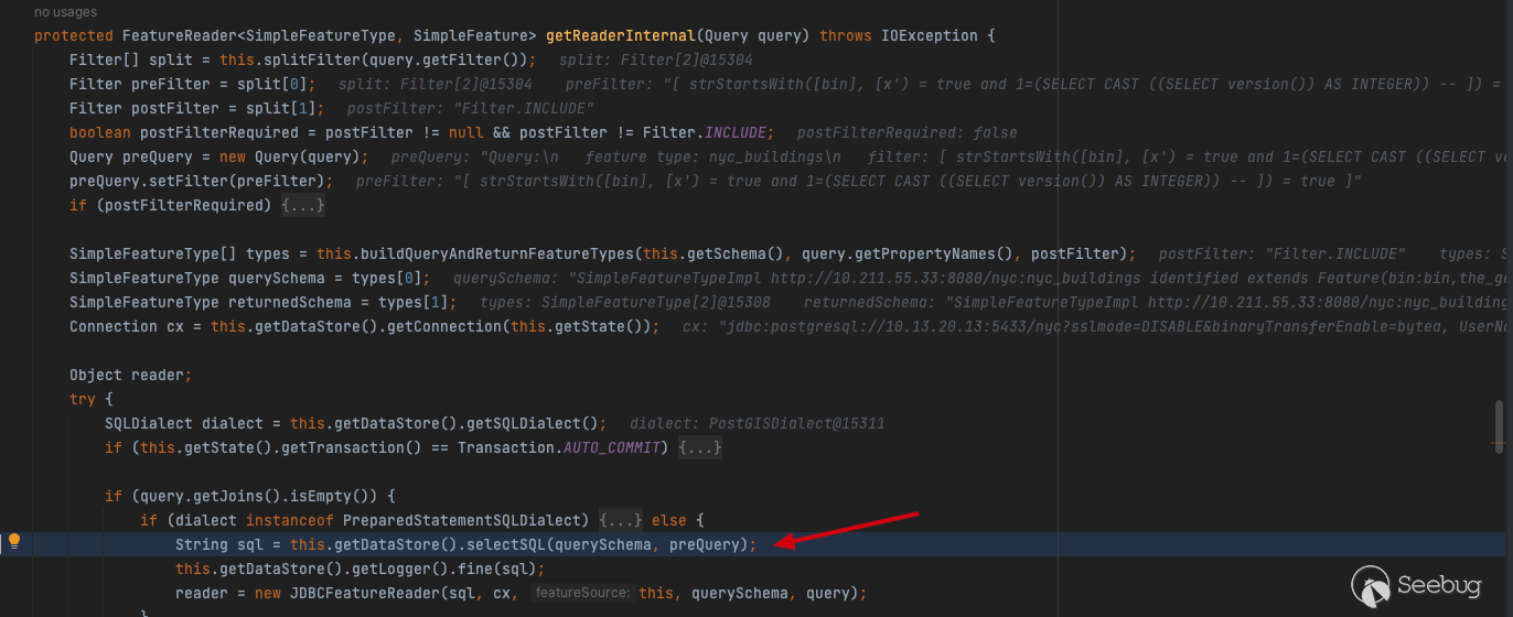
select now()will be executed to determine whether the database can be connected properly before querying this.getDataStore().getConnection(this.getState());
Follow up to selectSQL
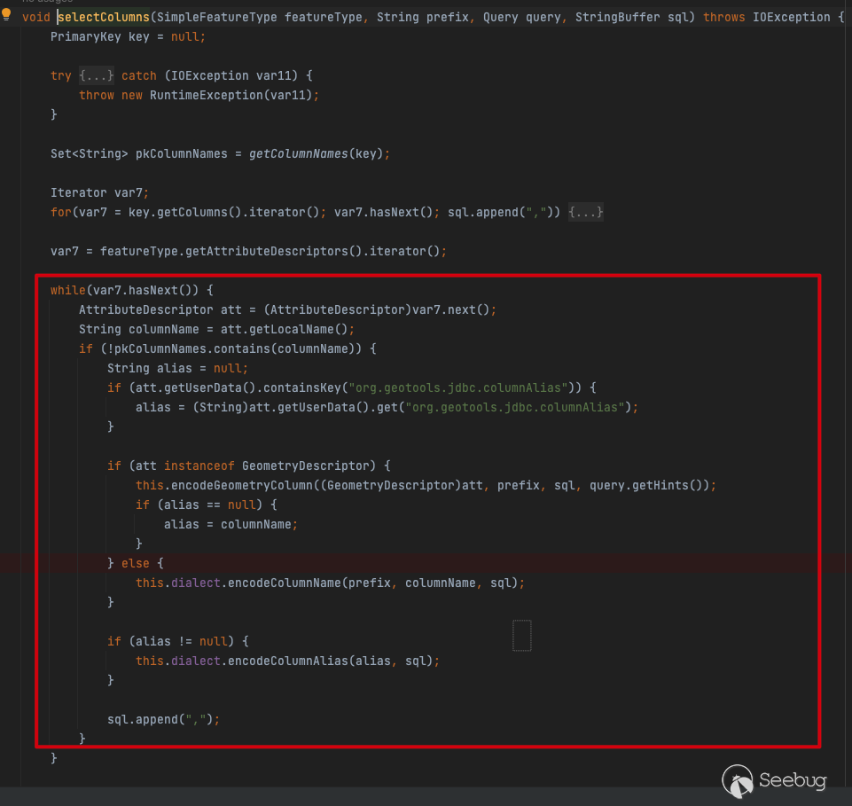
 In the
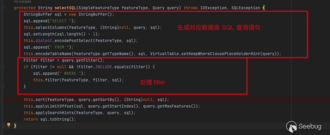
 selectSQL function, selectColumns traverses the columns in the database and concatenates SQL statements
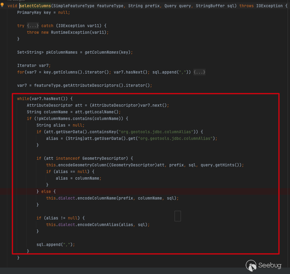
The concatenation correlation function is as follows:
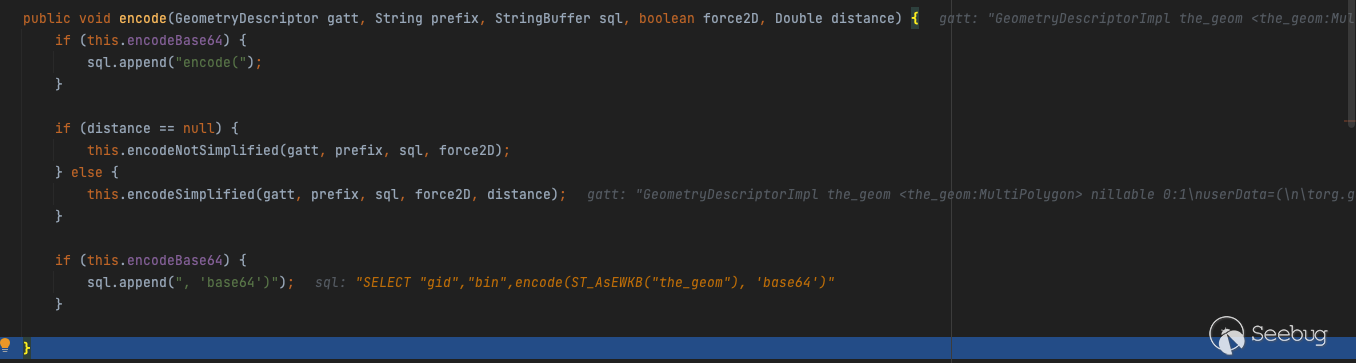
The SQL statement after concatenation is as follows:
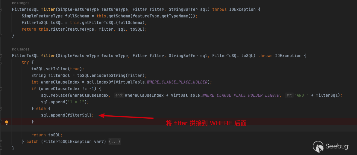
SELECT "gid","bin",encode(ST_AsEWKB("the_geom"), 'base64') as "the_geom" FROM "public"."nyc_buildings" WHERENext comes the handling of filter
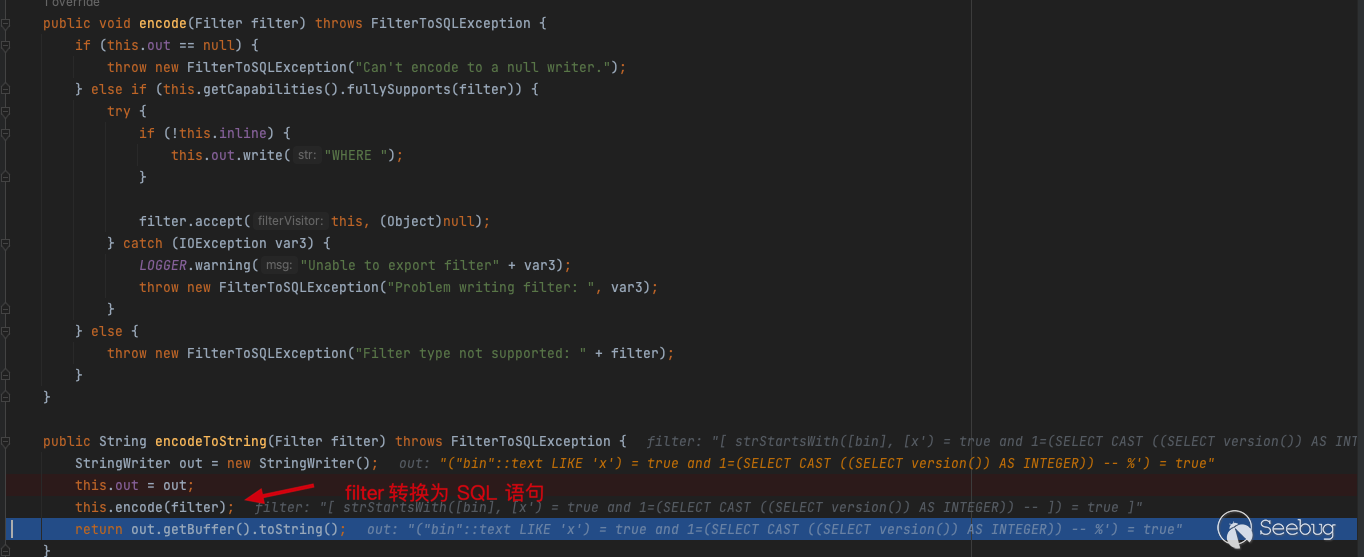
Convert the previously entered CQL_FILTER into an SQL statement and concatenate it after WHERE in filter
Therefore, the final concatenated SQL statement is as follows:
SELECT "gid","bin",encode(ST_AsEWKB("the_geom"), 'base64') as "the_geom" FROM "public"."nyc_buildings" WHERE ("bin"::text LIKE 'x') = true and 1=(SELECT CAST ((SELECT version()) AS INTEGER)) -- %') = trueExecute SQL statements in the JDBCFeatureReader by executeQuery
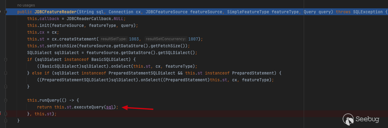
To sum up: the getReaderInternal() function under org.geotools.jdbc processes the query input by the user, and further calls selectSQL to generate SQL query statements corresponding to the database. After the query statement of the database is generated, the function determines whether the CQL_FILTER query condition exists. If it exists, the CQL_FILTER condition entered by the user is processed, and the CQL_FILTER is converted to an SQL statement by encodeToString(Filter filter). It is then concatenated after WHERE by the FilterToSQL filter. Finally, the JDBCFeatureReader 's this.runQuery executes the SQL statement with the injection to complete the injection.
The final call stack for the entire vulnerability is as follows:
<init>:153, JDBCFeatureReader (org.geotools.jdbc)
getReaderInternal:607, JDBCFeatureSource (org.geotools.jdbc)
getReaderInternal:218, JDBCFeatureStore (org.geotools.jdbc)
getReader:636, ContentFeatureSource (org.geotools.data.store)
features:173, ContentFeatureCollection (org.geotools.data.store)
features:52, ContentFeatureCollection (org.geotools.data.store)
features:40, SecuredFeatureCollection (org.geoserver.security.decorators)
features:75, SecuredSimpleFeatureCollection (org.geoserver.security.decorators)
features:93, DecoratingSimpleFeatureCollection (org.geotools.feature.collection)
encode:572, FeatureTransformer$FeatureTranslator (org.geotools.gml.producer)
parse:1054, TransformerBase$XMLReaderSupport (org.geotools.xml.transform)
transform:485, TransformerIdentityImpl (org.apache.xalan.transformer)
run:287, TransformerBase$Task (org.geotools.xml.transform)
transform:121, TransformerBase (org.geotools.xml.transform)
transform:103, TransformerBase (org.geotools.xml.transform)
encode:247, GML2OutputFormat (org.geoserver.wfs.xml)
write:261, GML2OutputFormat (org.geoserver.wfs.xml)
write:199, WFSGetFeatureOutputFormat (org.geoserver.wfs)
response:1018, Dispatcher (org.geoserver.ows)
handleRequestInternal:272, Dispatcher (org.geoserver.ows)
0x06 Fixes
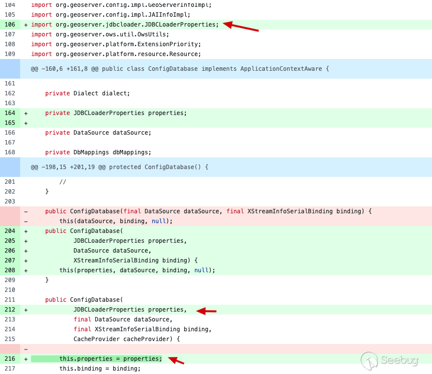
So far, GeoServer and Geotools have officially released repaired versions. The patches submitted by GeoServer add the moduleorg. Geoserver. Jdbcloader. JDBCLoaderProperties in thesrc/community/jdbcconfig/SRC/main/Java/org/geoserver/jdbcconfig/internal/ConfigDatabase.java The module is used for the configuration of jdbcconfig module property field under file jdbcconfig/jdbcconfig.properties , and change the constructor to include this attribute field.
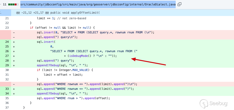
Moreover, official also changed the insertion syntax insrc/community/jdbcconfig/src/main/java/org/geoserver/jdbcconfig/internal/OracleDialect.java
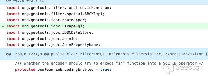
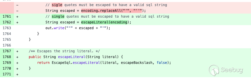
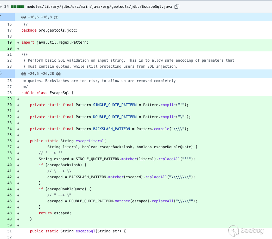
In the patch submitted by GeoTools, the official modifiedmodules/library/jdbc/src/main/java/org/geotools/data/jdbc/FilterToSQL.java added theEscapeSql module and escapeBackslash field to defend against SQL injection.
0x07References
https://github.com/murataydemir/CVE-2023-25157-and-CVE-2023-25158
https://docs.geoserver.org/latest/en/user/introduction/overview.html
 本文由 Seebug Paper 发布,如需转载请注明来源。本文地址:https://paper.seebug.org/2088/
如有侵权请联系:admin#unsafe.sh